


ELLY GRIMM
• Leader & Times
The City of Liberal has been working diligently to update its floodplain maps and Tuesday, the Liberal City Commission got to hear an update on that work.
Benesch Project Manager Joe File began his presentation with some history behind the project.
“Back in the 1970s, your floodplains were mapped using federal funds for the first time, and then in 1990, the City got its first flood insurance rate map,” File said. “That was the first time these floodplains were put on a map, and it was also about that time when the City was able to use these maps to administer insurance requirements under the Flood Insurance Rate Program. Moving forward to 2009, the Federal Emergency Management Agency (FEMA) came in and did an update to the flood insurance rate maps. Prior to that, the City would have maps just for the City of Liberal and then in the late 2000s-early 2010s, FEMA changed course and went to the county-wide maps, where all communities and jurisdictional boundaries within a county were mapped county-wide. At that time, Liberal’s floodplains were re-delineated – they weren’t restudied, the water surface elevations weren’t changed, but the boundaries were delineated on two-foot contour topography. So the City got a somewhat better delineation of the boundaries, but that was still from a study that had been done in 1986, so the floodplain maps the City has today are from engineering that was done then. Since that time in 2009, there have been 65 Letters of Map Change – some of those would be LOMRs from individual homeowners trying to get their homes out of the floodplain, and some of those would have been Letters of Map Revision driven by City development in order to revise the floodplain maps to continue to develop, and also recognize all of the flood control improvements the City has put into place throughout the past 20 or 30 years.”
Work then continued on the project into last year, File continued.
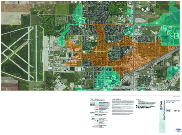
“Fast-forward to 2023, and the Kansas department of Agriculture (KDA), which is a cooperating technical partner with FEMA, initiated and completed a discovery project with Base Level Engineering (BLE) for the entire Cimarron Watershed, which includes Liberal,” File said. “In February 2023, these floodplains were first presented to Liberal, and those initial results looked really bad and were really, really inaccurate. At that time, City of Liberal staff started talking to the KDA about what could be done since the maps didn’t make much sense, and that’s when Benesch was engaged to help address those issues. We’ve done this work all over the state, but really, all over FEMA Region 7 and in the broader area. So we were somewhat familiar with this type of problem, and that’s when we were contacted. Through a scoping effort with the City of Liberal and city staff, we talked about a number of issues with these maps, and there have been a number of drainage-related improvement projects that have been completed throughout the years to help improve the flooding situation in Liberal that were not included in that BLE project that was done by one of the state’s contractors. That project didn’t account for any of the storm sewer infrastructure, so any of the water that goes underground, it just ignored that. Overall, the modeling was just very pooly refined, and it didn’t have the level of detail needed in order to accurately reflect what happens in the city. As a result, the City got these floodplains that didn’t really make much sense.”
File then talked more about the collaboration between Benesch and the City of Liberal for the project.
“In working with the City of Liberal, we developed a project scope to collect some new topography for those drainage projects that were done. We did that using a drone LiDAR machine, and essentially, that helped us re-map the ground surface for the areas of those projects,” File said. “That helped us more accurately map all the channel improvements that were completed and all the detention improvements so all of that could be included in the new modeling. We also did field collection of the stormwater drainage network, which makes up a majority of the larger conveyance structures within Liberal that help move stormwater from one place to another. From there, we developed an entirely new Hydrologic & Hydraulic (H&H) model, which models rainfall, runoff, and how that water moves over the ground to establish new water surface elevations. All of that work is work FEMA and the KDA, utilizing FEMA funding, they typically can’t fund, don’t fund. So by doing this project yourselves, you were able to gather all of this information that helped us reduce the size of the floodplains and come up with something that was much more accurate and would help when updating new floodplains for insurance rate maps.”
After going into more detail on some of the map drafts, File then talked about some of the impacts the new data will have for the city.
“We were able to collect that new topography with a drone that would not have been able to be done by FEMA, and the same goes for the survey of the stormwater network,” File said. “We’ve done some additional analysis and we’ve been able to significantly improve the modeling. We’ve got this draft floodplain, and there are two paths forward that have been discussed for multiple months now. The first option would be to incorporate this into the county-wide study – we are one of the state’s three floodplain mapping contractors and if we go that route, what would happen is the state already has the funding to move this forward, and there would be no additional costs to the City of Liberal, and this data would get rolled into their project and would go into that timeline. This would be what I would recommend – and not just from a cost perspective, though that is certainly a factor to consider, but more so because we know the reviewers, we’ve worked with them, and they’re good at what they do and could maybe even make some suggestions. They also understand Western Kansas, the project manager lives in Cimarron, so they understand the area. The other path forward is doing a LOMR (Letter Of Map Revision), and this would be one of the biggest LOMRs allowed by FEMA. What concerns me the most about this option is how most of the reviewers for this are set on the East Coast and are absolutely not familiar with Western Kansas and how water moves in this area. They’re more used to anything with 3 square miles of drainage, has water with a base flow that flows all the time, so they just don’t understand. And the time it would take to help them get familiar with the area would be an inordinate amount of time, which would delay all of this even more than it already has been. Something to note is how, due to the City’s project, the KDA was able to convince FEMA to fit the county’s project into the FY23 budget rather than wait for the FY24 budget, and because of the City’s initiative, KDA was able to convince FEMA to fund these two phases as one project, which would greatly reduce the overall timeline. We were initially looking at having effective maps at the beginning of 2029, but with this accelerated timeline, we’re now looking at having effective maps by December 2026, which is huge.”
In other business, the commission approved Resolution 2417 concerning the authorization of the offering for sale of General Obligation Temporary Notes, Series 2024 for the solar project that was recently approved and also set the commission’s Sept. 24 meeting for a public hearing for the establishment of the Rural Housing Incentive District (RHID) and the adoption of the development plan for Larry Street and Hickory Street. The commission also approved the purchase of new scoreboards from Varsity Scoreboards for an amount not to exceed $8,750.


