

ELLY GRIMM
• Leader & Times
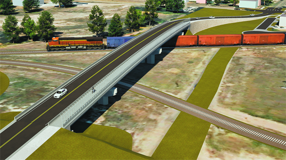
A new overpass in Liberal has been needed for many years, and a new project for just that is at a good point, according to a recent update.
“We are at a great point in this project, although of course we have a long way to go. But to me, it's feeling very real, so I'm very excited about this. For what’s being called the Liberal CARES (Crossing Analysis for Routes Enhancing Safety), we're working toward an RCE (Railroad Crossing Elimination) grant,” PCE Project Manager Robert Miller said. “For this project, the goal is to improve safety for local and highway users, support emergency service response time to better connectivity, increase the reliability of commuter routes to help reduce traffic congestion, improve mobility, reduce travel expense burdens, address pedestrian and active transportation user needs, and improve commuter accessibility. We are through the Federal Railroad Administration and we are going through a deeper process after the planning project is done, so all of this corresponds well into the purpose of finding a solution that fits all of those goals. As we go out to the community, starting with this meeting and with other announcements, and as we start developing a web page getting more information out there, of course people are going to ask where are we at. Prior to this, the City of Liberal was able to successfully get a grant for this project and move forward and we are now in what is called the planning phase. After the planning stage, we'll move into further work and documentation and also the preliminary engineering, and after that is final engineering design and final construction. The project is funded through the project development and planning, but not through design and construction, which is important to note. During the grant process, there were several locations that were looked at, and the intersections at Western Ave. and Pershing Ave. were the ones who really rose to the top. Clay Ave. was looked at, but it's too close to Pancake Blvd. and Kansas Ave., and you wouldn't want to do any improvements to Kansas Ave. since it's the main route of the downtown area. We are proposing a three-lane roadway of 11-foot travel lanes, a 12-foot two-way left turn lane on the roadway, a buffer strip, and then a 10-foot sidewalk. And again, we're in the planning stage, so there are no architectural details or lighting, those aspects will be something we'll be considering through the design process.”
Miller said there were many factors to take into consideration for the project, such as overall connectivity, drainage and other utility necessities for the proposed areas.
“With one of these options, in order to provide connectivity, Trail Street has a cul-de-sac and kind of a driveway section right there on both the alternatives, and for both the alternatives, the multi-use path is on the east side of the road, and that provides the best connectivity for the residents and the best connectivity for the neighborhoods on both sides,” Miller said. “We also had to look at the utility impacts – one has more utility effects, but most of those utility impacts were worth the homes being affected, so that's a trade-off to consider. With another option, there are more utilities, but they're home-related – the other utilities are with the actual power poles themselves With anticipated right-of-way acquisition, there are seven home properties that are on the north side of Trail Street and there are a lot of permanent right-of-way parcels that are also being acquired through there. The costs are about the same and I had to scratch my head and find out why were the costs the same – one of them has more permanent and the other one has more temporary construction impact, but they equaled out. So in terms of one versus the other in terms of cost, they were about equal. However, in terms of one versus the other in terms of the impact of the community, that's why we're going out to the community with the discussion and also to use the commission to determine what those are as well is there any questions on that or anything else.”
Local emergency personnel leaders have also given their thoughts on what would be more beneficial to them.
“For us, another bypass would be a boon because we're experiencing some issues now with where we’ve had to deal with constricted traffic on Kansas Ave. We've had some response delays to medical calls in the last couple weeks – in fact, the day of the bus barn opening, we had several times we were delayed, and because of the backed-up traffic on the bypass, we couldn't even get down there,” Liberal Fire Chief Kelly Kirk said. “We've got to have one of these. If your fire is on the west side of town, it's better to use Western Ave. Clay Ave. and Pershing Ave. are through routes, but they're very rough From Ohio Street north to 15th Street, that's where the issues lie with getting fire trucks to north and south, it's almost impossible to take a pumper and definitely the ladder truck through there because there are a lot of dips. Pershing Ave. is not a good transit from 15th Street going south. For our north trucks, Western Ave. is great and Clay Ave. is okay, but you still have the offsets. We're well suited on the south end but we're way to the east on Pine Street. Our north station's pretty well centrally located in a good spot. Our airport station right now, we're back to not staffing that because it's just not a great station and there's no room for us to put a pumper or a medical rig out there to transport. If we ever get the new terminal and parking lot put in and at a good point in the AIP planning, things could change with that. I think there was a plan for a new fire station and maintenance out there, and I don't know how far that will go or if the FAA will build a fire station out there that's big enough to accommodate a pumper and a medical rig. If that happens, then maybe we can put personnel out there to make it a functional third station for the city.”
“Most of our calls are either northeast or south for the most part for us,” County Fire Chief Mike Rice said. “We do go west once in a while, that would be Pershing Ave. as far as the county fire side of it. Western Ave. makes sense because if we go west, we take 15th Street to Western Ave. unless something's going on there like the recent construction. Pershing Ave. doesn't help us on the county fire side of it, and Western Ave. actually makes better sense for us for what we do.”
“Another consideration to take is what's going to happen to the migration to traffic once they put everything in and you've got one bogging down around National Beef, where 20 or 30 percent of traffic is going to flow once you get a second bridge,” EMS Director John Ralston said. “I think Western Ave. is better because it's wider and you're going to have better way to through traffic there. It should be part of the consideration of where is traffic going to migrate because it's going to space it out. People use the current bypass mainly to get over the tracks and then you're going to take half of those people that live on the west side of town, they're going to be using the other one so you're going to send that out a little bit.”
“We were clearly left out of a meeting because we do not share their opinion on this. I would point out what this is going to cause – by going further to the west, you're going to cause more traffic miles for people to have to drive back and forth because not everybody going to go to Western Ave. is going to stay on the west side of town, they're going to be coming back,” Liberal Police Chief Chet Pinkston said. “I have no way of knowing what the division of traffic is going to be between Country Estates Road, whether it's Pershing Ave. or Western Ave., but if you're talking about foot traffic – which we're talking about a 10-foot wide foot traffic bridge, who in the world going to walk all the way to Western Ave., walk across and cross over so that is something else to consider. I know whatever decision is made, there are going to be people who are happy and people who are disappointed, but from the Liberal Police Department side, we think the central location is probably more ideal for our purposes and for the purposes especially of the pedestrians.”